TerrainComposer
I can’t download the example package.
* Some users reported this. Here you can download the Example Package Unity 3/4 and Example Package Unity 5 directly.
When I want to create a heightmap layer and add a heightmap filter, choose heightmap output and click generate nothing happens. Why?
* In an earlier TerrainComposer version the default filter for the heightmap layer was on perlin. But some users where trying to input a heightmap and it got mixed with the perlin curve, so that give wrong results. So I decided to make the default filter flat. If you want perlin you have to click the ‘Curve’ button next to the visual curve and choose -> Line -> Default Perlin. Now if you click generate the perlin will appear.
The TerrainComposer window does not show anymore when I click it in the Unity menu.
* Sometimes it happens that an EditorWindow is floating somewhere but isn’t visable anymore. This seems to be a Unity bug. What you can do to let Unity close all open EditorWindows is click in the Unity editor the ‘Layout’ button (it is in the top right), and choose ‘Default’. Now the TerrainComposer window will be closed and you will be able to open it again.
I am getting a getting control repaint error when importing a new TerrainComposer version.
* This is not serious and happens for one frame, because the TerrainComposer window is changed while it is repainted by Unity.
When I make manual changes with the Unity terrain tools, it will be lost again when generating with TerrainComposer.
* You can export heightmaps/splatmaps/trees and grass from the current state of the terrain. This can be done by choosing an output button and enabling the ‘Export’ button in the top of the TerrainComposer window. Then you can import this again in the first layer, so you can use other layers to generate on top of it. For heightmaps you need to enable height output, then activate the export button and there you can export the heightmaps. Then you add a heightmap layer, put it at the top with the ‘<‘ button. And set filter input to ‘Raw Heightmap’ and load your heightmap there. For splatmaps you need to enable splat output, then activate the export button and there you can export your splatmaps. Then you add a layer, put it at the top with the ‘<‘ button. And set filter input to image and in settings enable ‘Splatmap’.
My terrains get overwritten in my old Scene from my new Scene, why does this happen?
* TerrainComposer uses standard Unity terrains. Unity terrains are not stored in a Scene or in the TerrainComposer project, but in a folder in your project as a class of TerrainData with the file extension .asset. TerrainComposer projects only saves all the settings and layers,etc, a very small file which can be used in runtime to generate terrains on the fly, or in a new Scene to regenerate new terrains. What you see in the hierarchy is a Terrain instance which references to the TerrainData in your project. So in the Hierarchy it’s not the real terrain. If you create a terrain with TerrainComposer you can choose the folder and filename to save it to in your project. If you create terrains with the example ‘Create Terrain’ button, the terrains are automatically stored in the folder TerrainComposer Examples/Terrains. So if you want to use the example terrains in different Scene, you have to create the terrains with the TC Terrain list one, where you can choose the file and folder.
You can drag and drop terrainData’s from the project in the Hierarchy window to get a Terrain instance from it. You can also drag and drop the Empty GameObject parent TerrainComposer makes (where all terrains are child of) into your project to create a prefab from it. If you drag and drop the prefab into a new Scene your terrains with the right positions will be there again.
WorldComposer
The heightmap of the created terrain is looking blockery.
The heightmap resolution for each terrain tile can be selected in the ‘Create Terrain’ tab. For the exported raw heightmap the correct size is automatically chosen and is 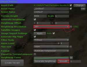 displayed behind between the parentheses, and this will also give best quality v.s. performance. However you can manually change this resolution. for example if you manually want to create more detail on your terrains with carving out a rivers. If you select a higher resolution, the heightmap of each terrain tile will have a higher resolution then in the exported raw file, this will result in the terrain looking blockery, and you will need to use the smooth button, which can be pressed multiple times. If you export to TerrainComposer, you can smooth there in Quick Tools -> Smooth.
Webplayer Mode
If you are in WebPlayer Mode you will get this error:
You are trying to load data from a www stream which had the following error when downloading.
Rejected because no crossdomain.xml policy file was found
This is because of the protection level, to solve it do the following:
Unity Menu -> Edit -> Project Settings -> Editor…Then in Inspector change ‘Host URL’ to http://dev.virtualearth.net
I get white satellite images with a no-camera symbol when I export my area.
This happens because Bing does not provide the zoom level of the area you are exporting. Not all the world coverage has the same zoom level and image quality. The best image quality and highest zoom level are the USA and most of Europe. What you need to do is choose a lower ‘Image Zoom’ in the ‘Image Export’ tab. You can check if an area has the zoom level you want by zooming to this level in the WorldComposer map (with the mouse scroll wheel), you can see the WC map zoom level in the ‘Map Parameters’ tab.